The 7 Continent system is flawed.

Joined Dec 2023
298 Posts | 181+
United States of America
The idea of dividing the world into huge geographical regions originated in Ancient Greece. Strabo and others called the lands west of the Aegean Sea Europe, the lands east of the Aegean Sea Asia, and the lands south of Greece, mainly Egypt, Africa (actually Libya, but there was a name swap). Roman expansion spread this idea throughout Europe and nearby regions. During the Age of Exploration, Amerigo Vespucci named the huge lands west of Europe to be America. Later on, Australia and Antarctica were discovered. Peter the Great designated the Ural Mountains as the eastern boundary of Europe.

In the 1900s, Plate Tectonics were discovered and they don't neatly match up with Earth's idea of continents. The Ancient Greek view of the world also isn't helpful from a pure political view because there are major sociopolitical differences between countries of the same continent & countries from different continents that are very similar. I'm proposing that the idea of continents is split into two ideas, geology and politics. Geological map of Earth will be restricted to plate tectonics, mountain ranges, rivers, physical features, etc. and feature no borders. The political map of Earth will be purely based on international borders and cultural realms.

1280px-Tectonic_plates_%282022%29.svg.png

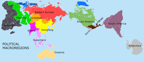
North America should be split into two political macro-regions: Anglo-America and North Latin America. Anglo-America would include USA, Canada, Belize, the Bahamas, and English-speaking Caribbean islands. North Latin America would include all Spanish-Speaking countries/territories north of Colombia. South America would be unchanged, but it could be renamed to South Latin America.

Europe would be split into two macro-regions, Western Europe and Eastern Europe. Western Europe would include every European country west of Croatia (not including it). Eastern Europe would include the rest of Europe.

Modern-day North Africa, West Asia, and the Caucasus will be combined into one macro-region known as Mashriq. Sub-Saharan Africa will be one large macro-region. The South Asia subcontinent will be renamed to Bharat. Southeast Asian macro-region will be called Nusantara. East Asian macro-region will be called Dongfang.Central Asia and Siberia will be known as Turkestan. Oceania macro-region will keep its name.

This way, people from South Asia and East Asia won't be collectively referred to as Asians despite all of their differences. Berbers and Egyptians will also be part of the same region as Arabians, who they have much closer ties to as opposed to the Congolese. There will no longer be any debates on whether Mexico is North American or Central American, or if Australia is an island or a continent. It never made sense to me anyway that Europe was its own continent, but Arabia and India didn't get to be continents despite the major geographical and cultural uniqueness there.
 
Joined Aug 2016
12,409 Posts | 8,400+
Dispargum
Yes, continents only describe land forms. They are used to teach children to identify countries on a map by size, shape, and location. Continents don't really serve any other useful purpose.
 
  • Like
Reactions: Graham S
Joined Oct 2016
11,512 Posts | 3,691+
Australia
You mentioned Australia as a continent and island but what about its 'macro - region ' ?
 
Joined Mar 2014
11,707 Posts | 3,483+
Beneath a cold sun, a grey sun, a Heretic sun...
I haven't asked them, but I'm quite sure the indigenous inhabitants of the Americas would object to the titles of "Anglo" and "Latin" America.
 
  • Like
Reactions: charlie ia
Joined Dec 2023
298 Posts | 181+
United States of America
You mentioned Australia as a continent and island but what about its 'macro - region ' ?
The macro-region or even continent Australia is part of is called Oceania.
I haven't asked them, but I'm quite sure the indigenous inhabitants of the Americas would object to the titles of "Anglo" and "Latin" America.
Unfortunately, indigenous Americans don't politically control any nation in the Americas (except for maybe Bolivia), so geopolitical maps are made without their opinions. Anglo America and Latin America refers to the predominate languages in the respective macro-regions.
 
Joined Apr 2021
4,208 Posts | 3,217+
Italy
It's a convention, and conventions have a lot of inertia. Especially when they are spread throughout the world and have been held up for centuries. I don't expect the proposed reform will succeed.
 
Joined Dec 2023
298 Posts | 181+
United States of America
It's a convention, and conventions have a lot of inertia. Especially when they are spread throughout the world and have been held up for centuries. I don't expect the proposed reform will succeed.
True, it is unlikely that everybody will use my system instead. That said, simply viewing the world in different ways besides calling all of Asia one continent or assuming all Africans fit one stereotype would still be helpful.

I made a map for this:

Macroregions.png
 

Attachments

  • Macroregions.png
    Macroregions.png
    58.1 KB · Views: 5
Joined Mar 2019
2,086 Posts | 1,598+
seúl
Anglo-America and North Latin America. Anglo-America would include USA, Canada, Belize, the Bahamas, and English-speaking Caribbean islands. North Latin America would include all Spanish-Speaking countries/territories north of Colombia. South America would be unchanged, but it could be renamed to South Latin America.
I haven't asked them, but I'm quite sure the indigenous inhabitants of the Americas would object to the titles of "Anglo" and "Latin" America.

nothing like dividing a continent along ethnical/linguistic lines, oh yes...


Unfortunately, indigenous Americans don't politically control any nation in the Americas (except for maybe Bolivia), so geopolitical maps are made without their opinions. Anglo America and Latin America refers to the predominate languages in the respective macro-regions.

identity is made up of several layers. latin american is one layer. 'indigenous' might very well be another.

now, im also quite sure latin americans wont agree with this division. latin americans do not even agree with the one used in the anglophone world of 'north america' & south america', so probably u can get an idea about it.

btw, eastern europe swallowed half of asia??
 
Joined Apr 2021
4,208 Posts | 3,217+
Italy
True, it is unlikely that everybody will use my system instead. That said, simply viewing the world in different ways besides calling all of Asia one continent or assuming all Africans fit one stereotype would still be helpful.

Would it? In the USA? US students have one of the worst levels of geographic awareness, compared to the most advanced countries in the world. Are you sure that starting to ask them to learn names like Nusantara and Mashriq will be helpful for them?


I made a map for this:

View attachment 71167
 
Joined Aug 2020
2,826 Posts | 2,445+
Devon, England
True, it is unlikely that everybody will use my system instead. That said, simply viewing the world in different ways besides calling all of Asia one continent or assuming all Africans fit one stereotype would still be helpful.

I made a map for this:

View attachment 71167
Your map is very......wrong

The first thing I noticed is the inclusion of many Central European countries in your Eastern Europe which is odd given the wildly divergent political and cultural traditions. Also Finland in a political macro with Russia? What is this the 19th Century? If you are going to acknowledge Central Asia as separate then countries that were already strongly divergent in the 90s and thus the right side of the Forum cut off should definitely be so. But wait there is more! Dongfang? I mean....wait, what? The Republic of Korea and Japan again have wildly divergent histories and cultural and political norms from say Xinjiang. Why does Mongolia get to be its own thing but not Taiwan? The idea that Indonesia has a common political identity with Myanmar? I mean er....

Also the mash up that is Mashriq but seriously

Folks criticise US students for their ignorance of overseas nuances but this is next level.

The map seems to be based on no common denominator neither cultural ties, it happily cuts across those, political alignments, it ignores those, economic relationships, again ignored, climate? Fails there too.

As for former British India, well that is the only tie that holds Bharat together and stops many parts from wandering into other groupings.
 
Joined Apr 2010
50,373 Posts | 11,707+
Awesome
North Korea and South Korea in the same political grouping? Be interested to see how you're going to pull that one off.
 
Joined Oct 2020
4,573 Posts | 2,355+
Peabody, MA
Not sure how the 7 continent "system" is flawed, as it isn't hurting anyone. Who are the aggrieved parties?
 
  • Haha
Reactions: specul8
Joined Mar 2018
7,171 Posts | 8,195+
Inside a Heighliner
Last edited:
"You're way of partitioning the globe into large chunks based on broad generalisations is deeply flawed, instead we should use my way of partitioning the globe into large chunks based on slightly different broad generalisations" is not a very convincing line of argument.

There's something inherently creepy in pushing for the introduction of Orwellian NewSpeak as a way of shifting other people's thoughts (if the 7 continent partition even affects people's thoughts in a meaningful way at all). If the problem is that people think of Africans in terms of racist stereotypes because the word "Africa" exists (which is a big assumption), then inventing "Mashriq" and "Amahoro" would just lead those people to think of all of Africa and the Middle-East in terms of slightly different stereotypes. But, even if universally adopted, this would do absolutely nothing to combat the presupposed underlying problem: that people think in terms of stereotypes.

As in other threads, I'd advise @Rhymehouse to focus less on the language other people use to describe ideas, and focus more on understanding the underlying concepts themselves. Substantive issues are almost always more important (and far more interesting!) than the exact semantics used to talk about them.
 
  • Like
Reactions: RandomRodent
Joined Oct 2011
40,336 Posts | 7,521+
Italy, Lago Maggiore
We have already had occasion to deal with this.

"Continent" is human conception we can compare to the conception of "constellation".

Scientifically the continents should be different, but we don't care [and I don't see why we should care].
 
Joined Aug 2009
11,606 Posts | 5,289+
Athens, Greece
I'm seeing a Huntington clone in that map...

Anyway, in all similar maps, the only constant, uncontested region is always Antarctica.

It seems that no one (yet) has had funny notions about the identity of pinguins. Lovely birds! :D
 
  • Like
Reactions: RandomRodent
Joined Dec 2023
298 Posts | 181+
United States of America
@Rhymehouse: Why do you subsume the Maghreb under Mashriq, and why do you split Latin America?
Mashriq is essentially an indigeneous renaming of the Middle East and North Africa region. As for splitting Latin America, I originally did that so that I can keep South America as its own continent and connect the Spanish Caribbean to Mexico and Central America. In a future revision of the map, I will probably just have Latin America just be one huge macroregion and then have the Caribbean be its own unique region.
Your map is very......wrong

The first thing I noticed is the inclusion of many Central European countries in your Eastern Europe which is odd given the wildly divergent political and cultural traditions. Also Finland in a political macro with Russia? What is this the 19th Century? If you are going to acknowledge Central Asia as separate then countries that were already strongly divergent in the 90s and thus the right side of the Forum cut off should definitely be so. But wait there is more! Dongfang? I mean....wait, what? The Republic of Korea and Japan again have wildly divergent histories and cultural and political norms from say Xinjiang. Why does Mongolia get to be its own thing but not Taiwan? The idea that Indonesia has a common political identity with Myanmar? I mean er....

Also the mash up that is Mashriq but seriously

Folks criticise US students for their ignorance of overseas nuances but this is next level.

The map seems to be based on no common denominator neither cultural ties, it happily cuts across those, political alignments, it ignores those, economic relationships, again ignored, climate? Fails there too.

As for former British India, well that is the only tie that holds Bharat together and stops many parts from wandering into other groupings.
Finland was literally part of the Russian Empire a century ago and the USSR was Finland's largest trading partner; so Finland being part of Eastern Europe (which by the way does not mean Russian-aligned or even authoritarian) makes sense. Dongfang is literally just the Sinosphere renamed. Mongolia is not its own thing, it is part of Turkestan (although it can just as easily be part of Dongfang). Nusantara is just Southeast Asia renamed. Bharat is just the Indian Subcontinent renamed.

All of these political groupings already officially exist and are acknowledged in real life. I just did a lot of renaming and compartmentalization instead of trying to group all of Asia or all of Africa under one identity.
PNG is still chopped in half .
That's on purpose. Oceania (which is already an official region) has Papua New Guinea as separate due to different colonial histories. Political maps and geographical maps are fundamentally different.
North Korea and South Korea in the same political grouping? Be interested to see how you're going to pull that one off.
North Koreans and South Koreans are literally the same ethnic group. An insane dictatorship that arose in the 1950s doesn't suddenly erase a millennia of history.
"You're way of partitioning the globe into large chunks based on broad generalisations is deeply flawed, instead we should use my way of partitioning the globe into large chunks based on slightly different broad generalisations" is not a very convincing line of argument.

There's something inherently creepy in pushing for the introduction of Orwellian NewSpeak as a way of shifting other people's thoughts (if the 7 continent partition even affects people's thoughts in a meaningful way at all). If the problem is that people think of Africans in terms of racist stereotypes because the word "Africa" exists (which is a big assumption), then inventing "Mashriq" and "Amahoro" would just lead those people to think of all of Africa and the Middle-East in terms of slightly different stereotypes. But, even if universally adopted, this would do absolutely nothing to combat the presupposed underlying problem: that people think in terms of stereotypes.

As in other threads, I'd advise @Rhymehouse to focus less on the language other people use to describe ideas, and focus more on understanding the underlying concepts themselves. Substantive issues are almost always more important (and far more interesting!) than the exact semantics used to talk about them.
Historical revision is a major academic process. The fact that obsolete and incorrect ideas are being done away it doesn't mean that Big Brother is trying to erase the past. The point of my revisions is so that students of the future have an easier time learning the truth instead of having to learn something and relearn it later on because the old method had many flaws.
 
Joined Apr 2010
50,373 Posts | 11,707+
Awesome
Last edited:
North Koreans and South Koreans are literally the same ethnic group. An insane dictatorship that arose in the 1950s doesn't suddenly erase a millennia of history.

Ah, so this map is ethnically based, not politically.

And maybe now you'll tell me the Japanese and the Chinese are the same as well?

Or maybe all Subsaharan African people are the same as well?
 

Trending History Discussions

Top